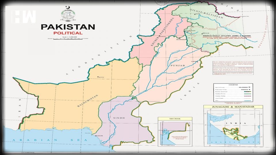
New Delhi, tearing into the map, called it a “ridiculous assertion without any global credibility”, and emerged on the first anniversary of the decision to scrap special status for J&K under Article 370.
New Delhi| Describing a map released by Pakistan that includes Jammu and Kashmir, Ladakh, and parts of western Gujarat, the Government on Tuesday called it “political absurdity”.
New Delhi, tearing into the map, called it a “ridiculous assertion without any global credibility”, and emerged on the first anniversary of the decision to scrap special status for J&K under Article 370.
Pakistani Prime Minister Imran Khan released the map on Tuesday.
“We have seen a so-called “political map” of Pakistan that has been released by Prime Minister Imran Khan. This is an exercise in political absurdity, laying untenable claims to territories in the Indian state of Gujarat and our Union Territories of Jammu & Kashmir and of Ladakh,” the government responded on the map.
“These ridiculous assertions have neither legal validity nor international credibility. In fact, this new effort only confirms the reality of Pakistan’s obsession with territorial aggrandisement supported by cross-border terrorism,” it further added in its response.
Pakistan Prime Minister unveiled the map on Tuesday, that he claimed negated India’s “illegal action of August last year” – a reference to the withdrawal of special privileges to J&K under Article 370.
Khan also went on to say that the map has been endorsed by Pakistan’s cabinet, was backed by its political leadership, and would be used in schools.
Earlier, Nepal’s National Assembly, the upper house of Parliament, unanimously passed the Constitution Amendment Bill to update the country’s political and administrative map incorporating three Indian territories- Kalapani, Lipulekh, and Limpiyadhura.
India had called Nepal’s “artificial enlargement” of territorial claims “untenable”. The comments came after its lower house of parliament unanimously approved the new political map of the country featuring areas that India maintains belong to it.
In a move described by New Delhi as “not tenable”, Nepal’s ruling and opposition political parties voted in unison to amend the constitution to update the national emblem by including in Nepal’s new political map, Kalapani, Lipulekh and Limpiyadhura, locations in India’s Uttarakhand.
As an independent media platform, we do not take advertisements from governments and corporate houses. It is you, our readers, who have supported us on our journey to do honest and unbiased journalism. Please contribute, so that we can continue to do the same in future.

