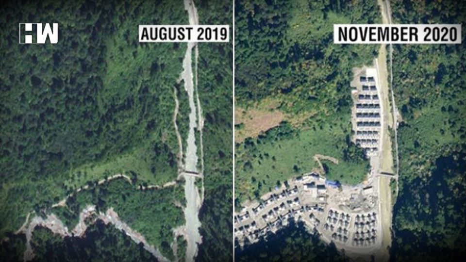
According to satellite images accessed by NDTV, China has constructed a new village in Arunachal Pradesh, consisting of about 101 homes.
According to satellite images accessed by NDTV, China has constructed a new village in Arunachal Pradesh, consisting of about 101 homes. According to NDTV’s report, the same images, dated November 1, 2020, have been analysed by several experts, who confirmed that the construction, approximately 4.5 kms within Indian territory of the de facto border, will be of huge concern to India.
Located on the banks of the River Tsari Chu, the village in question lies in the Upper Subansiri district, an area which has been long disputed by India and China and has been marked by armed conflict.
While Indian and Chinese soldiers confronted each other in their deadliest clash in decades in Western range of the Himalayas in Ladakh, the construction took place thousands of kilometres away in the eastern range of the Himalayas during the conflict.
The image accessed by NDTV of this village is dated November 1, 2020. However, the image dated a little more than a year before that – August 26, 2019 – does not show any construction activity. This makes it clear that the village was set up in the last year.
The Foreign Ministry, in response to NDTV’s detailed questions with the latest picture attached, did not challenge what the pictures show.
“We have seen recent reports on China undertaking construction work along with the border areas with India. China has undertaken such infrastructure construction activity in the past several years.”
As per NDTV, the government says it remains committed to improving border infrastructure. ”Our Government too has stepped up border infrastructure including the construction of roads, bridges etc, which has provided much-needed connectivity to the local population along the border.”
The BJP MP from Arunachal Pradesh, Tapir Gao, had raised the issue in November 2020, when he warned the Lok Sabha of Chinese incursions in his state, referring specifically to the Upper Subansiri district. In conversation with NDTV this morning, Mr Gao also said that this includes the construction of a new double-lane road. ”Construction is still going on. China has entered more than 60-70 kms inside the upper Subansiri district if you follow the path along the river. They are constructing a road along the river known locally as the Lensi as it flows in the direction of the Subansiri river.”
On NDTV’s question on whether the village construction has been diplomatically raised with Beijing, Foreign Ministry did not respond directly but said: ”The government keeps a constant watch on all developments having a bearing on India’s security and takes all the necessary measures to safeguard its sovereignty and territorial integrity.”
NDTV procured the images from Planet Labs Inc, satellite imagery experts who monitor the planet on a daily basis.
An authentic online map of the Surveyor General of India, used by the government as its official map, clearly shows that the Chinese village lies well within Indian territory, the report stated.
As an independent media platform, we do not take advertisements from governments and corporate houses. It is you, our readers, who have supported us on our journey to do honest and unbiased journalism. Please contribute, so that we can continue to do the same in future.

